Neogeography, which essentially means "new geography", can be defined as a depiction of the real world through geographic information and maps. What is so different and radical about this type of geography is that the person creating maps does not need specific master’s degree in cartography or geography information systems or extensive training. Map making has fully become publicly accessible that anyone with a sense of location, direction, and ability to describe places can create a map. One of the programs that helps average people with little or no knowledge of map-making is the Google program “My Maps”. Through this application, I was able to create my own map for this lab assignment. The concept of neogeography has infinitely transformed the way people view the world through maps. When comparing neogeography to traditional geography, we should look at how each type of geography is observed. Traditional geography looks at the actual topography and physical locations and professional people creating maps for a specific location or region do not have biases and personal opinions about that place. There is no bearing on how the map looks like because of their personal affiliation with that area. On the other hand, neogeography gives everyone and anyone to make maps that pertain to their liking and tastes such as the map I created of Mammoth, California. Also, neogeography does not include any formal or analytical foundation. Most importantly, the main difference between neogeography and traditional geography is the contrast in accuracy and precision of map production.
One of the best features of neogeography is that it has made the world smaller place and personal maps make this even more possible. With rapidly developing technology like Smartphones, GPS devices with their extremely spot-on parallel multi-channel design, and resources that are free to the public like Google or Yahoo Maps, everything in the world has come virtually closer. This makes it more convenient and easier for many people to view the millions of places in the globe on a computer or phone screen. Neogeography has forever changed people navigate around places, physically and virtually. With new technology, come many possibilities. Also, it makes map-making more interactive and allows for the person making the map to include a sense of closeness to the region.
The drawbacks of neogeography include the following reasons. Even though technology is in a sense faster, more precise, and oftentimes more reliable than people, because it is man-made, it is not perfect. Neogeography is not always accurate and reliable. Computers and phones are often faulty and internet service isn’t readily available everywhere on Earth. Certain atmospheric factors and other sources of error can also affect the accuracy of GPS devices and phones with GPS embedded in them. Sometimes, neogeography does not leave room for personal creativity and adventure. Why waste a whole day trying to navigate through a foreign city with a regular map with no guidance to where the best restaurants and shopping centers are when other people’s maps of where to go are available online? Also, it makes people dependent on GPS devices and cannot go anywhere without them. Today, many people do not rely on their memory to drive to a different city and instead, solely rely on technology. Neogeography has become so ever-present that it is making people ignorant and less willing to learn addresses and street names.
Here is the map I created with Google Maps application, My Maps. It is of the different restaurants and shops in Mammoth Lakes, California:
View Mammoth! in a larger map
Thursday, April 21, 2011

Wednesday, April 13, 2011
Lab#2: USGS Topos
1. What is the name of the quadrangle?
The name of the quadrangle is “Beverly Hills Quadrangle”.
The name of the quadrangle is “Beverly Hills Quadrangle”.
2. What are the names of the adjacent quadrangles?
The names of the adjacent quadrangles are the following: Canoga Park, Van Nuys, Burbank, Topanga, Hollywood, Venice, and Inglewood.
The names of the adjacent quadrangles are the following: Canoga Park, Van Nuys, Burbank, Topanga, Hollywood, Venice, and Inglewood.
3. When was the quadrangle first created?
The quadrangle was first created in 1966.
The quadrangle was first created in 1966.
4. What datum was used to create your map?
The datum used to create this map was the North American Datum of 1927 and the National Geodetic Vertical Datum of 1929.
The datum used to create this map was the North American Datum of 1927 and the National Geodetic Vertical Datum of 1929.
5. What is the scale of the map?
The scale of the map is 1:24,000 (unit on the map: unit on the ground).
The scale of the map is 1:24,000 (unit on the map: unit on the ground).
6. At the above scale, answer the following:
a) 5 centimeters on the map is equivalent to how many meters on the ground?
5: 5x24,000… 5cm: 120,000cm= 1,200 meters on the ground
b) 5 inches on the map is equivalent to how many miles on the ground?
5: 5x24,000… 5in: 120,000in= 1.89 miles on the ground
c) one mile on the ground is equivalent to how many inches on the map?
1 mi (on the ground): 63,360 in
63,360/24,000 (24,000 is the scale of the map) = 2.64 inches on the map
d) three kilometers on the ground is equivalent to how many centimeters on the map?
3 km (on the ground): 300,000 cm (on the ground)
300,000/24,000 = 12.5 centimeters on the map
a) 5 centimeters on the map is equivalent to how many meters on the ground?
5: 5x24,000… 5cm: 120,000cm= 1,200 meters on the ground
b) 5 inches on the map is equivalent to how many miles on the ground?
5: 5x24,000… 5in: 120,000in= 1.89 miles on the ground
c) one mile on the ground is equivalent to how many inches on the map?
1 mi (on the ground): 63,360 in
63,360/24,000 (24,000 is the scale of the map) = 2.64 inches on the map
d) three kilometers on the ground is equivalent to how many centimeters on the map?
3 km (on the ground): 300,000 cm (on the ground)
300,000/24,000 = 12.5 centimeters on the map
7. What is the contour interval on your map?
The contour interval on this map is 20 feet.
The contour interval on this map is 20 feet.
8. What are the approximate geographic coordinates in both degrees/minutes/seconds and decimal degrees of:
a) The Public Affairs Building:
a) The Public Affairs Building:
34.08388°N, 118.43749°W
34°04’62’’N, 118°26’15’’W
34°04’62’’N, 118°26’15’’W
b) The tip of Santa Monica pier:
34.00778°N, 118.5°W
34°00’28’’N, 118°30’00’’W
34°00’28’’N, 118°30’00’’W
c) The Upper Franklin Canyon Reservoir:
34.1031°N, 118.4231°W
34°06’11’’N, 118°24’53’’W
34°06’11’’N, 118°24’53’’W
9. What is the approximate elevation in both feet and meters of:
a) Greystone Mansion (in Greystone Park):
570 feet or 173.74 meters
b) Woodlawn Cemetery:
140 feet or 42.67 meters
c) Crestwood Hills Park:
725 feet or 221 meters
10. What is the UTM zone of the map?
The UTM zone of the map is Zone11.
11. What are the UTM coordinates for the lower left corner of your map?
The UTM coordinates for the lower left corner of this map are the following: Zone 11, Easting 3615000, and Northing 3763000.
The UTM coordinates for the lower left corner of this map are the following: Zone 11, Easting 3615000, and Northing 3763000.
12. How many square meters are contained within each cell (square) of the UTM gridlines?
Each cell or square of the UTM gridlines contains 1,000,000 square meters, which is attained by 1km x 1km.
Each cell or square of the UTM gridlines contains 1,000,000 square meters, which is attained by 1km x 1km.
13. Obtain elevation measurements, from west to east along the UTM northing 3771000, where the eastings of the UTM grid intersect the northing. Create an elevation profile using these measurements in Excel (hint: create a line chart). Figure out how to label the elevation values to the two measurements on campus. Insert your elevation profile as a graphic in your blog.

14. What is the magnetic declination of the map?
The magnetic declination of this map is positive 14° east.
The magnetic declination of this map is positive 14° east.
15. In which direction does water flow in the intermittent stream between the 405 freeways and Stone Canyon Reservoir?
The intermittent stream between the 405 freeways and the Stone Canyon Reservoir flows from North to South.
The intermittent stream between the 405 freeways and the Stone Canyon Reservoir flows from North to South.
16. Crop out (i.e., cut and paste) UCLA from the map and include it as a graphic on your blog.

Thursday, March 31, 2011
Lab#1: SSC & Blog
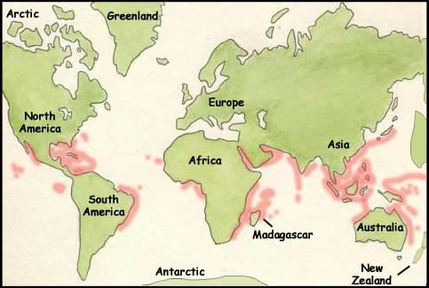
http://www.exploringnature.org/db/detail.php?dbID=44&detID=582
This map distinguishes where coral reefs can be found throughout the world. They thrive in warm climates along coastlines of most of the global continents. The map can be found on the Exploring Nature Educational Resource website, which subdivides different topics that are related to the the "living world", such as biomes, species, climates, and wildlife. A coral reef is a habitat, consisting of a plethora of biodiversity, which includes flora and fauna underwater. The website gives a brief description of coral reefs and characteristics. It is interesting to see that coral reef thrive so proximate to land that shows that there is a dynamic relationship between coral reefs and solid ground. The webpage also depicts what types of coral reefs exist near different continents. For example, "fringing reefs" live next to the shoreline of shallow water like around Hawaii and the Caribbean Islands. Another example can be shown on the map, the Great Barrier Reef, which is along the coast of Australia and reaches 1,200 miles long.

http://www.aaccessmaps.com/show/map/beverlyhillsarea#links

When I looked at this map, the first things that came into my mind were first, how I have never been to the Bahamas and second, how so many islands can exist within such a small area in the Atlantic Ocean. It is interesting to recognize the fact that a substantial amount of cultures existing next to one another. The Caribbean Islands had started being colonized by European powers since the 15th century and it is apparent that there are many traces of Europe's culture that shows in these specific islands. This is the reason behind the Caribbean's long history of colonization and slavery, which are basically passed on from generations to generations. As colonization spread, new cultures, languages, and the way the islands' distinctiveness was shaped developed also. The source of this map was a website with a general view of all the islands and how they as a whole make up a unique and mystifying place. Through this source, I have learned that most of the islands' histories do not coincide or reflect those of nearby ones. Most of them have differing origins and that is what intrigued me. There is so much more depth and entities that make up the Bahamas. Much more than beautiful beaches, clean, clear waters, and a well-deserved vacation spot. Each island possesses its own identity even though they are all extremely proximate to one another. The Caribbean region is a place of dream vacations and dense culture. It would be an amazing adventure to be there one day.
Subscribe to:
Posts (Atom)