http://www.exploringnature.org/db/detail.php?dbID=44&detID=582
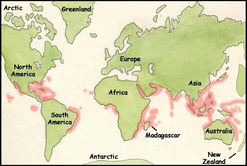
This map distinguishes where coral reefs can be found throughout the world. They thrive in warm climates along coastlines of most of the global continents. The map can be found on the Exploring Nature Educational Resource website, which subdivides different topics that are related to the the "living world", such as biomes, species, climates, and wildlife. A coral reef is a habitat, consisting of a plethora of biodiversity, which includes flora and fauna underwater. The website gives a brief description of coral reefs and characteristics. It is interesting to see that coral reef thrive so proximate to land that shows that there is a dynamic relationship between coral reefs and solid ground. The webpage also depicts what types of coral reefs exist near different continents. For example, "fringing reefs" live next to the shoreline of shallow water like around Hawaii and the Caribbean Islands. Another example can be shown on the map, the Great Barrier Reef, which is along the coast of Australia and reaches 1,200 miles long.

http://www.aaccessmaps.com/show/map/beverlyhillsarea#links

When I looked at this map, the first things that came into my mind were first, how I have never been to the Bahamas and second, how so many islands can exist within such a small area in the Atlantic Ocean. It is interesting to recognize the fact that a substantial amount of cultures existing next to one another. The Caribbean Islands had started being colonized by European powers since the 15th century and it is apparent that there are many traces of Europe's culture that shows in these specific islands. This is the reason behind the Caribbean's long history of colonization and slavery, which are basically passed on from generations to generations. As colonization spread, new cultures, languages, and the way the islands' distinctiveness was shaped developed also. The source of this map was a website with a general view of all the islands and how they as a whole make up a unique and mystifying place. Through this source, I have learned that most of the islands' histories do not coincide or reflect those of nearby ones. Most of them have differing origins and that is what intrigued me. There is so much more depth and entities that make up the Bahamas. Much more than beautiful beaches, clean, clear waters, and a well-deserved vacation spot. Each island possesses its own identity even though they are all extremely proximate to one another. The Caribbean region is a place of dream vacations and dense culture. It would be an amazing adventure to be there one day.
No comments:
Post a Comment